A City's Centre Is a Pattern, Not Just a Pin on a Map
Map a city centre as a pattern to see how main streets, connected districts and multiple hubs shape everyday routes and neighbourhood relationships.
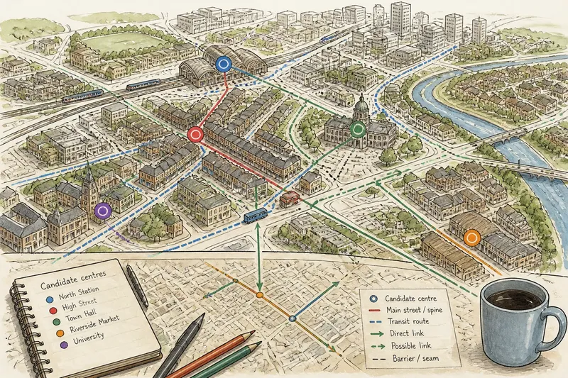
Open a city map and the bold dot marked “centre” can look like the whole story. Zoom in, though, and a railway station, market street, civic square and cluster of offices may each pull people in a different direction. To understand a city centre as a pattern, follow those clues and the routes linking them rather than trusting a single pin.
This is useful when comparing places, choosing an area to live in or trying to understand why one neighbourhood feels closely connected to another. You do not need specialist mapping software. A standard street map, a transit map and a little patience will reveal how a city’s centres and main streets fit together.
Start with a map that shows streets and everyday destinations
Choose a map where you can see street names, rail and bus routes, and recognisable destinations. A general online map is enough to begin. Switch off satellite imagery if roofs, trees and shadows make the street pattern hard to read. Keep the scale wide enough to include several neighbourhoods, but close enough that individual roads and junctions remain visible.
Look first for the city’s most prominent destinations: a central station, civic buildings, a large shopping street, a hospital, a university or a major market. These are clues, not a final list of centres. A place may attract visitors without functioning as a daily hub for nearby residents; another may be busy in local life despite having little visual prominence on the map.
Write down a short set of candidate places as you find them. Use actual names from the map, such as “High Street,” “town hall” or “North Station,” rather than labels such as “the main centre.” This keeps the investigation anchored to visible places instead of assumptions.
Begin with the map layer that makes street names easiest to read.
Mark possible centres before deciding which ones matter
Place a small mark beside each candidate destination or cluster. A centre is often a concentration rather than a single building: several shops, public services, workplaces and transport stops may gather around a square or along adjoining streets. A station on its own could be an interchange; a station surrounded by shops and services may also form a district centre.
Notice whether the marked places are close together or separated by large stretches of housing, industrial land, open space or limited crossings. Distance alone does not settle the question. A short walk across a continuous shopping street may feel like movement within one centre, while a similar distance across a railway cutting or a broad, difficult junction can divide two areas more sharply.
Now check what each cluster appears to serve. A civic complex may draw people during working hours. A cluster around a station may serve commuters and nearby residents. A market street might connect several neighbourhoods rather than dominate one compact area. These roles can overlap, and the map may not reveal opening hours or local routines. Treat the first round of marks as a working hypothesis.
Trace the main streets that give each centre shape
For every candidate centre, follow the streets that seem to lead into or through it. Look for a recognisable spine: a high street, a parade of shops, a road lined with local services or a route connecting a station to a civic square. Ask whether the street continues beyond the cluster or ends at a landmark, river, rail line or major road.
A continuous main street can make two clusters feel part of one larger centre. A break in shops, a change in street direction or a barrier may indicate that the city has several separate centres instead. The map may show these changes through street names, road layout and land uses, but it cannot tell you exactly how they feel on foot.
Follow side streets as well. A centre with several entrances and intersecting routes may connect naturally to surrounding districts. One with a single approach can be more inward-looking, even if it contains many destinations. Record the links you can see, not just the buildings at the destination.
Mark each main street as a line, then note where its character appears to change.
Check the connections between centres and districts
Next, trace the links between your marked places. Use transit routes to see whether a bus or rail line ties several hubs together. Then use the street map to check whether those stops connect to nearby streets, bridges and crossings. A route that passes through two centres can make them part of one urban network, even if neither depends on the other.
Pay attention to barriers and seams. A river may be crossed by only a few bridges; a railway may have underpasses far apart; a large road may interrupt short-looking local routes. Parks and open land can also separate areas, though paths through them may create useful connections. Do not assume that a coloured route line means every part of the journey is equally direct or convenient.
Separate direct links from possible links. A direct link is visible in the route or street network. A possible link is suggested by proximity but depends on details the map may not show, such as a locked entrance, a steep path or a crossing with limited access. This distinction keeps a neat-looking map from promising more than it can support.
Compare patterns without treating every centre as equal
With the candidate hubs, main streets and connecting routes marked, describe the city’s pattern in plain language. It might have one dominant centre and several smaller neighbourhood hubs, a chain of centres along a transit corridor, or distinct districts separated by physical barriers. These are descriptions, not grades. A city can have more than one pattern at once.
For each centre, note what seems concentrated there, what streets feed into it and which districts appear connected. Avoid ranking places by the number of map symbols. A cluster of symbols can represent a busy destination, but the map may omit informal activity, opening times and the practical quality of the route.
Say you are comparing two unfamiliar cities. In the first, a station, civic square and shopping street sit along one continuous route, with side streets reaching nearby districts. In the second, several neighbourhood hubs sit on separate corridors, with a river between some of them. Your map notes would describe a connected central spine in one place and a more distributed pattern with a physical seam in the other. They would not, by themselves, tell you which city better fits your needs.
What can a map reveal, and what should you verify?
How can I tell whether a city has more than one centre?
Look for several distinct clusters of destinations, each with streets or transit routes that draw people towards it. Then check whether they have their own main streets and links to surrounding districts, rather than being isolated landmarks.
Does a large station count as a city centre?
It can be one kind of centre, but a station symbol alone only shows a transport stop. Look around it for adjoining streets, services and connections to nearby neighbourhoods before deciding how much of a district it appears to anchor.
How can I spot a barrier between districts on a map?
Look for railways, rivers, broad roads, fenced land or large open spaces, then check where routes cross them. A nearby crossing may join areas, while widely separated crossing points can make two close-looking districts less directly connected.
Can a map tell me how lively a centre feels?
Not reliably. A map can show a concentration of destinations and routes, but it may not capture opening hours, pedestrian conditions or how activity changes during the day. Treat it as a way to form questions, then check local information or visit if that is practical.
Turn the map pattern into useful questions
Once you can describe the pattern, use it to decide what to check next. If a district seems tied to one main street, ask whether your likely destinations sit along it or require detours. If several centres appear connected by transit, check whether the relevant routes serve the times and places that matter to you. If a river or rail line divides the map, look closely at the crossings you would actually use.
For a closer look, compare the street map with a transit map and, where available, local council or neighbourhood maps. Walk imagery can help clarify junctions and street continuity, but it may be out of date or show only one point of view. For a move, visit at the times you expect to travel when possible; for a first comparison, keep claims tied to what the maps actually show.
A useful map note is specific: “shops and civic buildings cluster around the station, with a continuous high street toward the east” says more than “the station is central.” Use that sort of description to compare city centres as patterns, and the next map will offer better questions than a lone pin ever could.