The Walkability Myth: One Number Cannot Describe Every Errand
A walkability score can hide awkward everyday trips. Compare destinations and route barriers to see which neighbourhood makes your regular journeys easier.
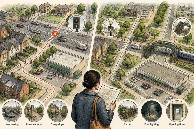
You can reach the corner bakery on foot, yet the supermarket sits beyond a busy road. A walkability score may compress both facts into one figure. To judge a neighbourhood’s walkability, look beyond the score and check how its streets connect the places you need.
A walkability score is a starting point
Scores offer a quick way to compare broad patterns. Depending on the source, a rating may reflect nearby destinations, street connections, density or other features. It can help distinguish a place with clustered shops from one where daily needs are spread out.
But a score cannot tell you whether a route has a safe crossing, a continuous pavement or a steep stretch you would rather avoid. Nor does it show whether the destinations counted are useful to you. A high score might reflect cafés and offices while a major road separates homes from the local health centre.
Different sources may count different destinations or draw neighbourhood boundaries in different ways. Two places with similar ratings can therefore have very different street layouts. Use the score to decide what to inspect, not as a verdict on access.
Check what the map reveals that the score misses
Open a map and look at the street network between homes and destinations. A straight-line distance can disguise a railway, a canal, a steep slope or a large block that forces a detour. A bridge or a single crossing may determine whether a nearby place feels reachable.
Compare routes rather than counting map pins. Look for continuous pavements, crossings where you need them, and streets that remain connected instead of ending at a barrier. If the journey depends on a footpath, check that it is open and suitable for the people who would use it.
For a closer look, use a street-level map image where available, then visit the area if that is practical. Observe the route at a time that resembles when you would travel. A calm street at midday may feel different near school drop-off or after dark.
Use a consistent set of route checks
For each place on your shortlist, start from a plausible home area and inspect the same kinds of connections. These checks focus on the physical route, not on compiling a catalogue of amenities.
- Crossings: Check whether you can cross the main roads along the likely route. If a crossing is available where you need it, keep the route in consideration; if not, compare a safer crossing or mark the detour as a drawback.
- Pavements: Check whether a pavement continues along the route. If it does, assess the rest of the journey; if it ends, look for a connected alternative or treat the gap as a barrier.
- Gradients: Check for steep slopes that could affect your journey. If the route is manageable for its intended users, keep it; if not, look for a flatter connection or assess another way to travel.
- Barriers: Check for railways, rivers, fenced land or large blocks between the starting point and destination. If a usable crossing or path connects both sides, follow it; if not, compare the required detour with a different route.
- Lighting and visibility: Check whether the route appears lit and easy to see at your usual travel time. If it seems suitable, retain it for further consideration; if visibility is poor, inspect another street or visit at that time before deciding.
- Opening and access arrangements: Check the destination’s hours and entrance details with the provider. If they match when you need to arrive, the route remains relevant; if they do not, check for another entrance, time or destination.
Each check should end with a decision. A route that looks short on screen may lose its appeal if a barrier turns it into a long detour.
How do you assess routes without a fixed home address?
What starting point should you use?
Choose a realistic block or small cluster of streets in each neighbourhood, rather than an arbitrary point at its centre. If your likely home area shifts, check the routes again; a nearby road or barrier can change the result.
Should you trust a map’s walking route?
Treat it as a route suggestion, not a confirmation of conditions on the ground. Check crossings, pavements and barriers yourself, and look for current local information where access may change.
How can you compare routes fairly?
Use the same kind of starting point and the same route checks for each place. Record what differs, such as a direct crossing in one area and a forced detour in another, then decide which difference matters more to you.
What if the route seems different at different times?
Consider the time you would usually travel, since traffic, lighting and activity can alter how a street feels. If the difference could affect your decision, inspect the route at that time or seek local information.
A worked comparison makes route trade-offs visible
Imagine you are comparing two invented neighbourhoods and have no confirmed home address. For this example, use one plausible starting block in each place and two destinations that matter to your household: a school and a supermarket. The details are invented, not observations about real places.
- Set the same checks: For both routes, inspect crossings, pavement continuity, barriers and the likely travel time. This keeps one neighbourhood from receiving an easier assessment.
- Inspect the school route: In invented neighbourhood A, the map shows a direct street, but a major road has no crossing near the school. In invented neighbourhood B, a marked crossing connects the starting block to the school, so B has the more usable route on this check.
- Inspect the supermarket route: In A, a continuous pavement leads to the supermarket without crossing the major road. In B, a railway forces a detour to a footbridge. A is the stronger option for this journey, while B’s route needs closer consideration.
- Make the decision explicit: If the school journey is the more important access concern, B may be the better fit, provided the footbridge route is workable for your household. If supermarket access matters more, A may suit you better; if neither route works, keep searching rather than letting a score settle the question.
The comparison does not name a universal winner. It shows which route conditions support each option and which unresolved detail needs a closer look.
Choose a walkability score only for the question it answers
If you are screening many areas, use a walkability score as a broad signal. If you want to know whether a route is physically connected, inspect the street network and its barriers. If a particular crossing or path could change your choice, verify that detail locally.
Keep the score in the background while you compare routes. The useful question is not simply whether a neighbourhood is walkable, but whether its street connections work for the journeys you expect to make.
When you revisit your shortlist, note both the route that works and the obstacle that could change your mind. That record makes a walkability-score comparison more precise and helps you see when another visit or local check is needed.